

|
|
| Lewis and Clark Bridge at Rainier |
|
|
| A street om Rainier |
"The town of Rainier was founded by Charles E. Fox, who settled there in 1851, and was the first postmaster. The name of the town was taken from mount Rainier. The earlier name was Eminence. Mount Rainier, in Washington, has been the center of one of the most acute geographic name controversies in the history of the country. It was named by George Vancouver on May 8, 1792, for Rear-Admiral Peter Rainier, of the Royal Navy.
Eminence post office was established June 5, 1851, with Charles E. Fox first postmaster. The name of the office was changed to Rainier on Jan. 6, 1852. Rainier is located on the Oregon bank of the Columbia River across from Longview and Kelso, Washington. Near Rainier, the mighty Columbia River turns West to make its final dash for the sea having run north from Portland.
In the latter part of the 20th Century, Rainier was overshadowed by the Trojan Nuclear power plant built and operated by Portland General Electric near Prescott a few miles up river. This facility was closed in 1993, and the cooling tower as demolished in a major implosion on May 21, 2006. A time sequence of the demolition is to be found here: Trojan demoliton photos.
Rainier is also the southern anchor of the Lewis and Clark bridge, the only bridge over the Columbia River between Portland and Astoria. This bridge allows Northwest Oregon residents immediate access to Interstate 5 and all points north. The Bridge also presents a unique challenge to Northwest Oregon. It was designed in the 1920's and construction was completed in 1930. It is a steel structure of the classic cantilever design with a main span of 1200 feet. Although modern for its time, the bridge is now seriously obsolete. Replacement was seriously considered in the runup to the deck replacement in 2003-04, but neither local consensus nor financing were found. Washington state does not classify the bridge as more important than 'local access', even though it is the only vehicle bridge between Portland and Astoria. There are few jobs in Oregon near Rainier and much of the historic bridge traffic has been that of local people who live in Oregon and work and shop in Longview which is a significant industrial center.
As per Wikipedia:
The bridge was open on March 29, 1930 as a privately owned bridge named the Longview Bridge. The $5.8 million cost was recovered by tolls, $1.00 for cars and $.10 for pedestrians. At the time it was the longest and highest cantilever bridge in the United States. The state of Washington purchased the bridge in 1947 and the tolls were removed in 1965 after the bridge was paid for. In 1980 the bridge was rededicated as the Lewis and Clark Bridge in honor of the Lewis and Clark Expedition. The deck was replaced in 2003-04 at a cost of $29.2 million.
The bridge is 8,288 ft. (2.5 km) long with 210 ft. (64 m) of vertical clearance. The main span is 1200 ft. (366 m) long and the top of the bridge is 340 ft. (104 m) above the river. It was designed by Joseph Strauss, engineer of the Golden Gate Bridge."
|
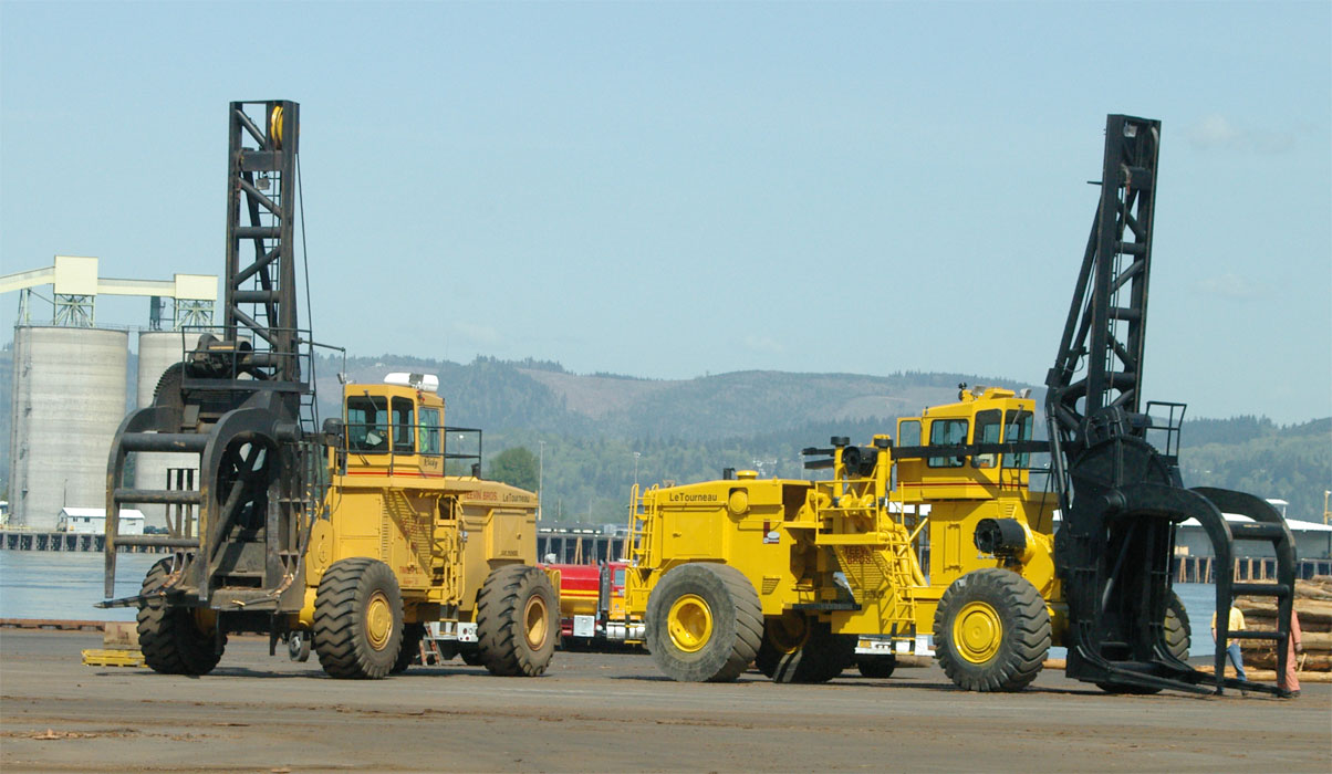
| LeTourneau Stackers at Rainier Sort Yard |
Rainier is a relatively old town with its origins dating to before statehood. Rainier had a historic opportunity to exist as it was a place along the Columbia River that you could get down out of the hills to the riverfront---not an easy task just any where. Not only could you get out of the hills, there was as Rainier no swamp land denying you access to the river. The Railroad went down A street along the river's edge, and the river front buildings and wharf's were generally on piling on the river side of A street. A century of dredging and dumping dredge spoils has created a lot more 'flat land'.
Historically, Rainier has been the site of several sawmills, and has served as 'home port' for a variety of Tugboat operators over the years. Tugs are not as prolific as they were in the past when roads and trucks were few. In times past there were many sawmills along the lower Columbia, and logs through the region were moved to 'the river' where they were rafted by booming companies. Ultimately some mill would buy the rafts, and a tugboat would then tow the raft to the appropriate mill.
In the early years you read of logging railroads and later about the shift to trucks. Initially neither went directly to the mill. Instead the logs went into the water. Sometimes this was a pond near the mill, but many times it was just a convenient place where the logs could be 'dumped'. To this day log truckers speak of 'dumping' their loads, because historically, they dropped the stakes and the logs were rolled into the river. Now however most stakes don't drop and logs are almost universally unloaded with the help of a giant fork lift.
Presently one of the major industrial activities at Rainier is a log sort yard located on the site of a former sawmill under the Lewis and Clark Bridge. Transport of logs by raft is no longer favored, but the yard provides an interchange point for lower river logs. Strategically located on the Portland and Western shortline railroad which has good service to downstate Oregon, this yard is able to receive logs by barge or truck (or rail) and ship them by barge, truck or rail. As I write this the yard is marshaling logs and forwarding them by rail to buyers primarily in Southwest Oregon at the rate of up to 30 rail car loadings a day.
See also Apiary for more on road.